|
Hiking in the Refuge
The Refuge offers multiple hiking trails of varying lengths, from easy to moderate difficulty. Trails are open from sunrise to sunset at each of the Refuge units: South Bay, Leadbetter, Long Island and East Hills. Trail descriptions and maps are shown below.
View the general location information map
|
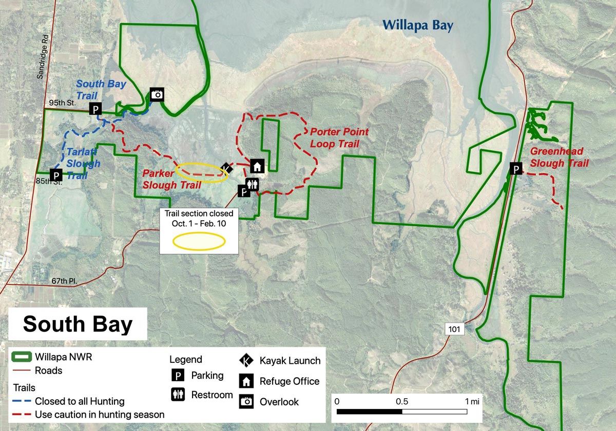
South Bay Trails |
Access South Bay trails from 95th Place (South Bay, Tarlatt Slough, and Parker Slough) or 67th Pl. (Porter Point Loop, Parker Slough). Directions95th Place: Travel north on Sandridge Road to 95th Place East and turn right; continue to the end of 95th. Parking is available along the gravel shoulder by the fence line – please do not block the gate. Directions, 67th Place: Travel north on Sandridge Road to 67th Place and turn right; continue to the parking lot on the right, just before the refuge headquarters gate. Greenhead Slough Trail is described in the Long Island and East Hills section below. | Porter Point Loop - 2.4 mile loopThis newest Refuge trail of moderate difficulty begins in a serene cedar swamp before climbing to and then descending from the ridgetop above Porter Point. Much of the trail is through regenerating forest on former logging roads. View large flocks of shorebirds and waterfowl in spring and fall along the bay side of the trail. Parker Slough Trail - 1.5 mile one wayThis moderately difficult trail connects the Porter Point Loop to the South Bay trail and winds through a marsh restoration and cedar and spruce forest with excellent views of the slough and Willapa Bay. The west portion of trail is closed Oct. 1 – Feb. 10. Tarlatt Slough Trail- 0.7 mile one wayAn information panel greets you at the trailhead to this scenic trail that goes through seasonal wetlands, open fields, and regenerating coastal forest. It is a good place to look for birds of prey, deer, geese and in summer an abundance of tree and violet-green swallows. South Bay Trail- 0.6 mile one wayWalk past a small grassland, through a coastal forest and experience unparalleled views of Willapa Bay at a scenic overlook at the end of this easy trail. During spring and fall this trail is an excellent place to see large flocks of ducks, shorebirds, and bald eagles. Lucky visitors may spot river otters, elk, and black bear. |
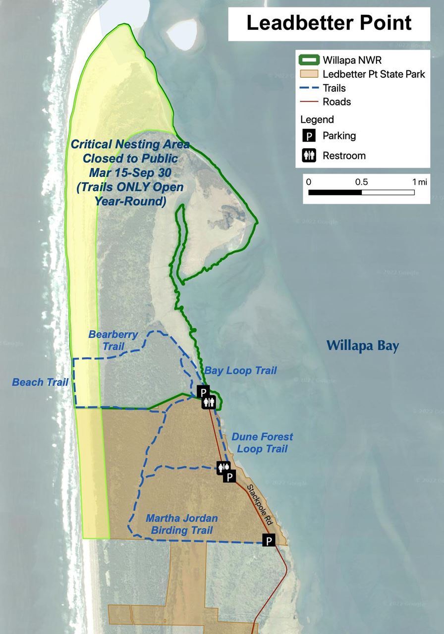
| Explore trails that wind along the bay and in the shore pine forest at the northern tip of the Long Beach Peninsula. DirectionsDrive north on Highway 103 (follow signs from Ocean Park and Oysterville), to the end of the road. Multiple parking areas are available on both the state park and wildlife refuge. Notes: A Discover Pass is required to park at Leadbetter. Trails can be flooded in areas from October through May. Critical bird nesting area – see map for portions of seasonal trail closures. Bay Loop - 1.1 mileThis easy loop takes you along the scenic bay where information panels share stories about the bay’s bird life and salt marsh habitat. Bearberry Trail - 1.3 mileTrek across the peninsula on this easy trail to the Pacific Ocean beaches. Look for the low-growing bearberry carpeting the forest understory. Beach Trail; 0.5 mileLinking Weather Beach to the Bearberry Trail, this beach route offers the promise of viewing hundreds of thousands of shorebirds in spring and fall. Follow all signs for nesting bird closures. Weather Beach; 1 mileFrom the Dune Forest Loop, stroll across the peninsula to the breaking surf. Along the way you will see seasonal wetlands within the dunes that support life in this harsh landscape. This trail also meets the south end of the Beach Trail. Dune Forest Loop; 2.8 milesThis trail winds through coastal pine forest and along Willapa Bay. |
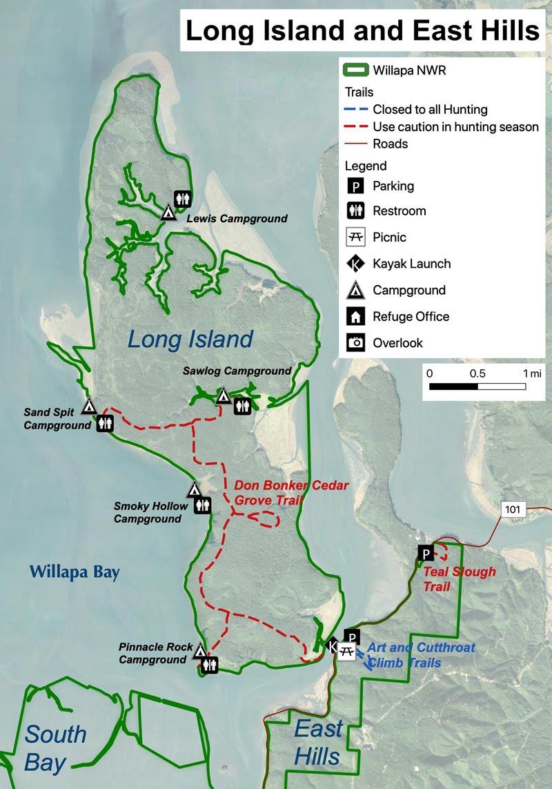
| Long Island TrailsExplore 10-plus miles of trails with access to beaches, meadows, and forest. DirectionsThe island is accessible by boat only; a public ramp is at milepost 24 on US Highway 101. Camping is allowed on the island. https://www.fws.gov/refuge/willapa/visit-us/activities/camping Notes
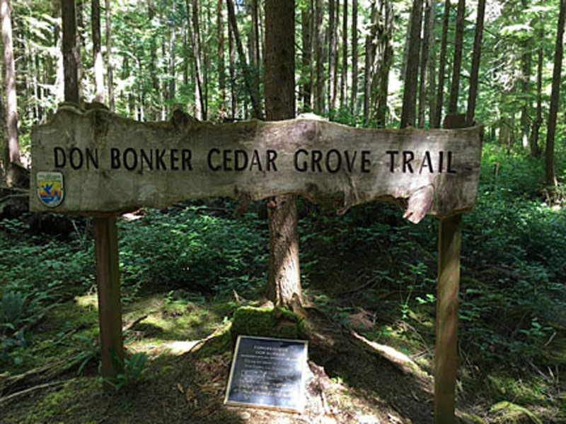
Don Bonker Cedar Grove TrailThis 1-mile loop has a 274-acre cedar grove with trees over 900 years old! To hike it, land your boat on the southern tip of Long Island and follow the center road north. The trail to the grove is about 2.5 miles from the landing. East Hills TrailsTeal Slough Trail - 0.5 mile one wayThis trail is just north of the old refuge headquarters and boat ramp on Highway 101. It is a relatively easy one-way 0.5 mile trek into a forest with relics from the past – gigantic old-growth cedar and Sitka spruce. Limited parking is on the east side of Highway 101 at the pullout. Art Trail - 1.25 mileThis one-mile Cutthroat Loop trail is at the old Refuge headquarters on Hwy 101. This is an interpretive art trail that is a short, easy, and accessible journey along a winding boardwalk above a tidal flat. Commissioned art along the trail teaches about the wildlife and habitat of the Refuge. Continue onto the Cutthroat Climb, a moderately difficult loop that rises and then falls steeply through a deep-wood of thick ferns and old-growth hemlocks. Greenhead Slough Trail - 0.5 mile one wayThis trail is approximately 4.5 miles south of the old Refuge headquarters on Highway 101 (see map on South Bay). This easy trail is along a gravel road that offers views of secondary forest and a 150-acre estuarine restoration that benefits salmon and brook lamprey. The trail ends after 0.5 miles and is marked by a gate. |
About UsVisit the Refuge | EducationEvents |